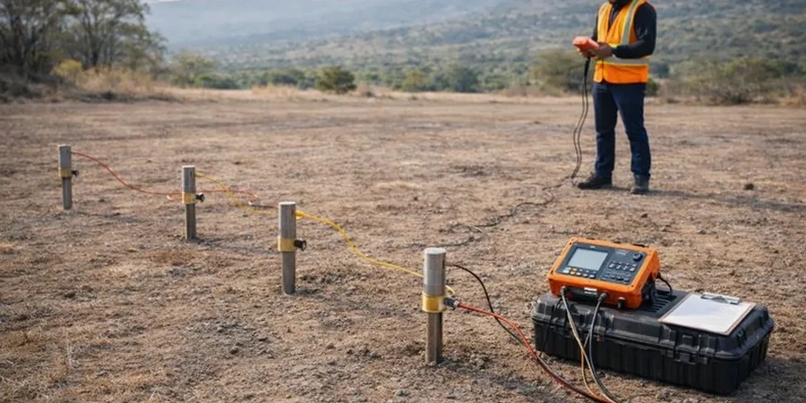
The 4-electrode array deployed across a Sioux City site extends Wenner or Schlumberger configurations—stainless steel stakes driven into Iowa loess at spacing intervals that double from 1.5 to 150 meters. Current injection through the outer electrodes creates an electrical field whose potential drop is measured between the inner pair, producing apparent resistivity values that the ABEM Terrameter logs at each expansion step. Because the Missouri River floodplain deposits underlying Woodbury County interbed saturated sands with glaciolacustrine clays, the resistivity contrast can exceed 300 ohm-m between coarse channel fills and tight overbank silts. The crew adjusts maximum AB/2 spread based on target depth: a 100-meter line yields interpretable data to roughly 25–30 meters below grade, sufficient for most foundation investigations in the metro area where bedrock lies deeper than typical SPT refusal depths. Post-acquisition, the team runs 1D inversion with smoothness-constrained least-squares algorithms, generating a layered resistivity model that distinguishes perched water tables from regional aquifer units—critical information when designing dewatering systems for excavations near the Floyd River channel.
Resistivity contrasts across Sioux City’s Missouri River alluvium often exceed 10:1 between clean sand and fat clay, making VES an efficient reconnaissance tool before committing to an invasive drilling program.
Methodology and scope
A recurring mistake among local contractors is assuming that resistivity alone can replace a boring log without considering equivalence and suppression effects inherent to the method. In Sioux City’s glacial stratigraphy, a thin 10-cm sand seam at 6 meters depth carrying perched groundwater may suppress the resistivity response of a thicker clay layer immediately beneath it, leading the interpreter to overestimate granular thickness if borehole control is absent. We address this by requiring at least one
SPT drilling point within the VES profile line, using the recovered split-spoon samples to calibrate the geophysical inversion and confirm that low-resistivity zones correspond to AASHTO A-6 or A-7-6 clays rather than saline pore fluid. The combination works particularly well on ridgeline sites east of Interstate 29, where loess thickness varies abruptly and the resistivity transition from dry to saturated loess—typically a drop from 80–120 ohm-m to 20–40 ohm-m—maps the seasonal water table position. For projects requiring continuous soil-behavior-type profiling without cuttings, the
CPT test provides complementary cone resistance and friction ratio data that further constrain the resistivity interpretation, especially in identifying thin compressible layers that could trigger differential settlement under mat foundations.
Common questions
How deep can a VES survey investigate in Sioux City's geology?
Practical investigation depth depends on the maximum current electrode separation (AB/2) and the local resistivity structure. With a 150-meter AB/2 spread—the typical limit for a single-station sounding on accessible lots—we obtain interpretable data to approximately 35–40 meters below ground surface in the Missouri River alluvium. Deeper penetration is possible but requires longer spreads that may be constrained by site boundaries or overhead utilities.
What is the typical cost range for a VES survey in Sioux City?
A single VES sounding with borehole calibration and a formal engineering report typically falls between US$670 and US$1,160, depending on line access, required AB/2 expansion, and the number of calibration boreholes available. Multi-sounding profiles or 2D ERT lines are priced per linear meter after the initial mobilization.
Does frozen ground affect resistivity measurements during winter months?
Yes—Sioux City experiences sustained freezing temperatures that can increase near-surface resistivity by a factor of five to ten as pore ice replaces liquid water. We either schedule VES surveys between April and November, or apply a seasonal correction factor derived from soil temperature monitoring at the site, which the inversion model incorporates as a frozen-surface layer constraint.
Can VES replace soil borings for foundation design?
No—VES is a geophysical reconnaissance method that maps electrical contrasts, not a direct measurement of engineering properties. ASTM D6431 specifies that resistivity data must be correlated with borehole control to convert interpreted layers into soil behavior types. We always pair VES with at least one strategically placed SPT boring to anchor the inversion and verify that a low-resistivity zone is indeed a clay layer rather than a saline sand.